Welcome to The Perverse Pennine Way Blog. Perverse in that I walked the ‘wrong’ way, north to south, and largely spurned indoor accommodation. For a more user-friendly walk, you might prefer The Pleasant Pennine Way Blog. I’m using ‘pleasant’ and ‘perverse’ for effect, obviously, in fact I enjoyed both itineraries more or less equally.
The north-south option offered an interesting opportunity: to schedule a walk ‘out of phase’ with the standard sequence of stopping points. Rather than experiencing open country by day then eating and sleeping in a built environment, the lie of the land suggested eating and resupplying during the day then maximally engaging with the countryside – gulp – at night. Click here to jump to my itinerary.

Padon Hill wild camp. Wild camp selfies are taken at dusk, hence not supersharp.
Don’t you love rationalisation? The truth is, once I’d realised wild camping at the south end of The Cheviot would have made a night at Colin and Joyce’s a scheduling nonsense, all subsequent accommodations would have been an anticlimax. I figured I might as well wrap myself in a bin bag and sleep in ditches.
Once the mad idea of an ultralight Way with maximal wild camping had rooted in my head, it couldn’t be shifted, not even by the non-availability of another clear three weeks of my life until October. October, for goodness’ sake. I ordered a tiny tent to be hand-sewn by tiny Scottish pixies, and a tiny rucksack that, compared to my trusty old cordura monster, appeared to be made from chip paper and shrimp nets. Some said I had unordered my tiny mind.
Company and comfort don’t compromise the Pennine Way, they just make it different. Walking alone and camping wild are no indicators of bravery or toughness – I’m spectacularly deficient in both those enviable qualities.
As the song doesn’t say, there’s only one Pennine Way and that’s your own. If you fancy walking The Way in a group of jolly friends, paying for baggage transfer and carrying only grouse paté sandwiches, Westwood waterproofs, an Internet-enabled iHydration system and gold-plated Compeed between your pre-booked luxury hotels, please do so, The Way needs you. One day I will grow up and do exactly that myself, in fact I’m positively looking forward to it.
Wild camping in England is illegal without the landowner’s permission but in high, wild country, barring chainsaw-wielding hillbillies on crystal meth, the worst thing likely to happen is that a representative of said landowner will detect you and require you to move on. For the sake of goodwill and the bigger picture you must do so at once, politely and without shirtiness, whatever the hour and the inconvenience.

Cross Fell wild camp.
This hasn’t happened to me on the Pennine Way, everybody I met was friendly and supportive. Publicans, dog walkers and even gamekeepers cheerfully suggested campsites. Keep a low profile, pitch late, leave early, use discrete equipment. You’re not up there to show off or party, just to shelter and sleep, and even this is only acceptable on a zero impact basis. You must refrain – obviously – from lighting a fire and leave absolutely no trace of your stay; this in particular includes toileting, evidence of which drives landowners (and fellow walkers) quite reasonably round the twist. As Baden-Powell said, leave two things at a campsite: nothing and thanks.
If you’ve the sense you were born with and can tolerate those simple restraints, then do try wild camping. I think it has important psychological and political (with a small p) dimensions. I respect and accept the property rights from which I, as a homeowner, benefit every day, but I also feel informal sleeping out is an important experience for everyone. It’s part of establishing and reasserting our need and our right to engage with and authentically experience the precious little wild countryside that we have left.
Below is my bare-bones itinerary with links to blog posts. The basic pattern was four nights’ wild camping, as much as I could stand in October, then a dry-out in a hostel. Short days were an issue. Distances and elevations are estimated and rounded; they’re just for rough initial planning.
Hilltop camping can be life threatening and is only for confident, experienced campers with bomb-proof gear and a Plan B. Use your own judgement; please monitor weather forecasts and local evolving conditions. I’m not an outdoor expert, this blog is for anecdotal entertainment only; it describes the Pennine Way as it was in October 2016 and will not be updated. Please only use it as a supplement to planning your own unique adventure using up to date information.
The Perverse Pennine Way blog:

Pre-day:
Travelled by train to Berwick upon Tweed and stayed at YHA hostel (pre-booked).

The Schil
Day One: Kirk Yetholm to Lamb Hill
16 miles, + 3890 ft, – 2850 ft.
Bus to KY via Kelso, wild camped on Lamb Hill, ~ 500 m.

Byrness
Day Two: Lamb Hill to Padon Hill
15 miles, + 1810 ft, -2090 ft.
Wild camped on Padon Hill, 370 m.

Bellingham
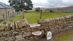
Day Three: Padon Hill to the mysterious sheepfold, via Bellingham.
17 miles, + 1600 ft, – 1830 ft.
Wild camped in the mysterious sheepfold.

The sheepfold
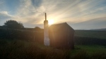
Day Four: The mysterious sheepfold to Black Hill via Greenhead.
16 miles, + 1670 ft, – 1740 ft.
Wild camped on Black Hill, 290 m.
Merry Knowe
Day Five: Black Hill to Alston via Knarsdale.
14 miles, +1640 ft, -1610 ft.
Hostel at Alston, pre-booked via YHA.

Greg’s Hut
Day Six: Alston to Cross Fell.
11 miles, +2320 ft, – 340 ft.
Wild camped on Cross Fell, 890 m.

High Cup
Day Seven: Cross Fell to Cauldron Snout via Dufton.
17 miles, + 2360 ft, – 3800 ft.
Wild camped at Cauldron Snout, 420 m.

Kirkcarrion
Day Eight: Cauldron Snout to Race Yate via Middleton.
20 miles, + 1940 ft, – 2110 ft.
Wild camped at Race Yate, 420 m.

Great Shunner
Day Nine: Race Yate to Great Shunner Fell via Tan Hill and Thwaite.
19 miles, + 3100 ft, – 2180 ft.
Wild camped on Great Shunner Fell, 710 m.

Great Shunner
Day Ten: Great Shunner Fell to Hawes.
7 miles, + 130 ft, – 1620 ft, a rest day.
A planned easy day, I stayed at Hawes Hostel (YHA – pre-booked).

Penyghent
Day Eleven: Hawes to Fountains Fell
22 miles, + 3690 ft, – 2520 ft.
Wild camped on Fountains Fell, 540 m.

Malham
Day Twelve: Fountains Fell to Malham
8 miles, + 340 ft, – 1800 ft.
An unplanned easy day, I wimped out and stayed at Malham Hostel (YHA).
Ickornshaw
Day Thirteen: Malham to Ickornshaw Moor via Gargrave.
21 miles, + 3000 ft – 2250 ft.
Wild camped on Ickornshaw Moor, 440 m.

May’s Shop.
Day Fourteen: Ickornshaw Moor to May’s Shop.
13 miles, + 1760 ft, – 1830 ft.
Camped at May’s Shop.

Stoodley Pike
Day Fifteen: May’s Shop to Northern Rotcher.
16 miles, + 2200 ft – 1890 ft.
Wild camped at Northern Rotcher, 420 m.

Black Hill
Day Sixteen: Northern Rotcher to Bleaklow.
17 miles, + 3140 ft, – 2520 ft.
Wild camped on Bleaklow, ∼ 600 m.

Kinder
Day Seventeen: Bleaklow to Edale.
12 miles, +1139 ft –2370 ft
Bed and Bath and Breakfast at Ollerboook Barn (pre-booked). The following day a train from Edale to Sheffield and thence home.
Gear Notes.
I walked in trail shoes this time and my feet enjoyed it far more than they did either of my previous two booted efforts. On the Pennine Way in anything other than actual snow or ice I’d always now walk in shoes.
I used a Trekkertent Stealth 1 tent (a nifty little thing but I had terrible condensation issues), a Montane Ultra Tour 40 backpack (fragile and uncomfortable), Alpkit Carbonlite Ultra trekking poles (unreliable) and Salomon X-Ultra GTX shoes (which leaked and one of the silly non-replaceable laces wore out). Don’t you just love outdoor gear?
I hope you find my posts useful and encouraging if you’re contemplating the Pennine Way. I’ve done it three times and I’d happily do it again, although I’m neither tough nor particularly fit. It’s a great walk…


Thanks. Did S to N last year but thinking of N to S as soon as the virus thing passes and can get out. Your stages are useful to see.
LikeLiked by 1 person
I prefer trail or approach shoes to boots (my Dad did too although he broke his ankle on Brandreth wearing shoes).
I’d do the Pennine Way north to south – I’d have thought that was the normal way? From the worst weather to the better weather. The northern end must be tougher walking too?
Love your camping advice from Baden-Powell – spot on! I’m too soft to wild-camp. I often sleep in my car in lonely spots but am too lazy to carry the weight of a tent (I usually walk very lightweight) and I hate getting cold and wet, being cold and wet all evening/night and then having to put wet gear back on and stow wet tents away in bags (making them even heavier!)
LikeLiked by 1 person
Most people walk the PW south to north, as per the guidebooks. I’ve never found there’s much to choose weatherwise between Kinder and The Cheviot. I can’t decide if I’d do a N-S again, it just felt wrong somehow. You meet people who say they prefer it, but they’re normally the kind of people who eat Mars bars in horizontal layers 😉
LikeLike
Hi andrew i came across your blog last year and you encouraged me to try the pennine way.So i decided to do 4 days N/s having my last night at haltwhistle campsite.But Iam giving it another go this year see how far i can get in 2 weeks.my navigation skills are really poor so i managed using the OS map APP. Could you tell me how difficult is it to navigate the full P.W iam guessing your old school paper map and compass.Any advise is appreciated .Thanks the happy hiker from byker…
LikeLiked by 1 person
Hi Andrew. On my first PW I was lost at some point pretty much every day!! But that was in 1999 before smartphones. If you use any of the guidebooks then north to south becomes confusing as the books tend to run south to north. I’d start out by getting OS paper maps. Cicerone do a book that’s just the maps but I think the best option looks to be the A-Z ‘adventure atlas’ maps that come in two volumes, I’ve looked at these in bookshops and they seem to be just what you need, slim, light and practical. You need some way of keeping them dry, personally I just use plastic bags and carry spares. Get hold of a compass, it doesn’t have to be fancy, and look at some of the tutorials online, there are some on the OS website I think. Then you’re safe if your phone fails. I’ve never needed to walk a bearing super-accurately on the PW, but being able to take bearings from a map approximately has many times saved me from taking wrong turnings. You don’t have to worry about magnetic declination as presently the difference is so small. What you do need to worry about is whether your compass is anywhere near your phone, which will badly confuse it.
With a smartphone you then have extra navigation superpowers. First level – if you get the free ‘OS Locate’ app, that will give you a grid reference that instantly tells you where you are on your paper OS map when you’re lost. This has got me out of trouble on the PW loads of times. Next level – get an actual mapping app and then download into it the GPX file off the National Trail website. Underneath the interactive map on the PW page you’ll see a tab for ‘GPX Downloads’. Once you have this file on your phone you should find the OS Maps app will read it. However I personally found OS Maps extremely unreliable in the absence of fast mobile data which you can’t rely on in the hills and so I personally use OsmAnd instead. That only works on Android and you need a phone with a memory card for the maps as they’re huge, about 3 GB. But with OsmAnd you can then navigate in airplane mode and with no signal. The app and maps are free but you need the contour lines plugin which cost me about £3.50. Other mapping apps are available and in general Facebook groups are good places for advice, the Pennine Way Walkers group is great. Thanks for visiting the blog and best wishes, A
LikeLike
Thanks👍⛺️
LikeLike