Having the luxury of retirement, I went and hiked the whole Scottish National Trail in one go, fairly slowly. However for walkers without five weeks to spare, the trail splits quite neatly into two ‘halves’, each of roughly two weeks, on either side of an additional three days in the Cairngorms
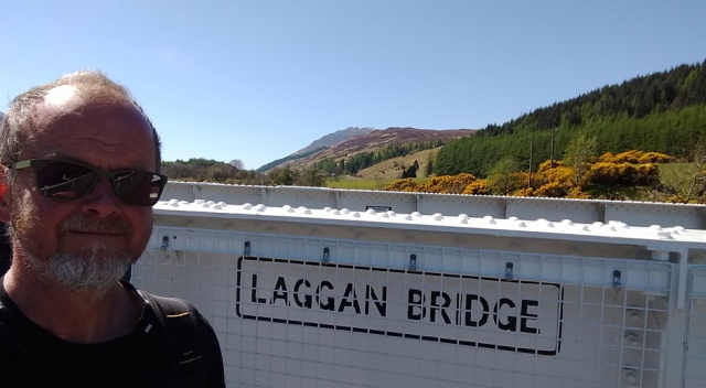
Both Blair Atholl and Kingussie are accessible by train and from the Borders to Blair could be done in a fortnight. The Cairngorms section could be a separate long weekend. Then for another fortnight, given good weather, the SNT takes us from Kingussie to Cape Wrath. This is a variation of the Cape Wrath Trail which normally starts at Fort William. From Laggan Bridge the routes are identical, insofar as they are routes at all.
I say this because in fact neither the SNT nor the CWT have any visibility on the ground, at least not in the form of waymarkers, interpretive information panels, safety warning signs, leaflets and all the other obtrusive paraphenalia of the trail industry. I very much hope they stay that way.

OK, there are some safety signs…
‘But won’t I get lost without waymarkers?’ Personally, with the GPX waypoints from WalkHighlands imported into OsmAnd on my phone and Iain Harper’s excellent guidebook Walking the Cape Wrath Trail I found navigation straightforward. I got lost once, for an hour or so in Gleann Dubh on the way to Inchnadamph, but that was because I was in a hurry and had neglected to study the map in Harper’s book carefully enough. I was glad of the GPS to quickly put me right, although I could probably have managed in the end with the compass which of course I also carried.
I didn’t bother with OS maps, but then I could afford a certain nonchalance on the navigation because I was carrying a tent and food. Hence even if I became disoriented, the chance of my actually dying was small. Having now completed this walk and experienced the remoteness of the terrain and the genuinely astonishing rapidity with which the weather flips from benign to extreme, I can easily imagine how walkers without survival gear could get into serious trouble out here. The Cape Wrath Trail is a non-trivial expedition through the wildest country remaining in the British Isles and it does need to be approached with a modicum of respect.

The last view of the Great Glen, looking back northeast from above Laggan Bridge.
The other thing it needs to be approached with is a camera, or at least a half-decent smartphone in my case. The landscape is stunning. As I was using the phone for navigation it was always to hand, so I ended up taking a completely ridiculous number of photos. I now need to cut the waffle and post a few of them, or this blog will go on for ever.

Beautiful pinewoods near Mandally.
After the pretty woods at Mandally, however, the landscape of Glen Garry is not so much stunning as stunned. Not only does the trail follow an obtrusive and boring bulldozed track, a bafflingly wasteful and destructive form of forestry has left most of the valley littered with an incomprehensible volume of waste timber. As well as brash and root plates there are umpteen cut branches and numerous felled trees that presumably didn’t meet some tight specification for removal. It’s quite impossible to venture off trail through the thick tangle of cut wood and the swamps and pools it conceals. More to the point, it’s also impossible to pitch a tent anywhere.

Boring track through blasted landscape – Glen Garry.
I’ve never seen ground covered in such a thick layer of waste timber and it seemed to me that an ecosystem quite novel in modern times has been created here. It ought to be a bonanza for saproxylic insects, although in a conifer monoculture I suppose diversity will be small. There must be creatures adapted to this habitat, though, as in the early post-glacial I imagine pine forests must routinely have been levelled by fierce storms. It will be fascinating to see what develops here in terms of wildlife, but for a walker in May 2017 Glen Garry wasn’t particularly exciting, although of course thanks to the track at least route finding was trivially easy.
This other-worldly, shattered and littered terrain was frustrating as I’d hope to camp along the trail around 28 km from Fort Augustus. The small farmstead at Greenfield had some tent-friendly pasture but that would have entailed asking permission and there was nobody about. I found nowhere else sensible to pitch a tent until Garrygualach. This made a long day of around 35 km, but it didn’t feel too arduous as there was very little climbing and I’d had two easy days previously. An Osprey fished over the loch behind me as I pitched the tent in beautiful evening light

I’d hoped to camp around here at the Allt Ladaidh but the terrain was hopeless

At Garrygualach I finally found a small patch of flat, dry ground.
The WalkHighlands directions had warned of another difficult river crossing at the derelict cottages here, so I was relieved to find that not only were the cottages in fact being restored but a nice new bridge had been installed just in time for my arrival. Reassuringly, the directions have since been updated to reflect this.

The wonderfully remote cottages at Garrygualach are being restored.

This was the old bridge.

And this, thank goodness, is the new one.
In general, it looked to me as if the days when you could buy a Highland ruin for pennies are over. In fact there seemed to be something of a land grab going on, abetted by the ugly vehicle tracks being bulldozed into even the remotest glens for the forestry and the hydro. Even the most unpromising half-wrecked hovels in the middle of nowhere were often decorated with a pile of building materials and an upscale SUV. At Kingussie I saw a local newspaper headline: ‘Highlands’ population increasing by a thousand a year!’ That’s one street in Bracknell or Croydon, but up here after centuries of vanishing villages and unviable schools it’s a big deal.

Glen Garry at dawn.
Day 24, May 4th, Garrygualach to Alltbeithe hostel. West of Garrygualach, the Cape Wrath Trail introduces itself to you properly with four or so kilometres of really quite grotty bogs, partly redeemed by nice views of the River Garry to your right and of the mountains ahead.
I ate my crunchy bar brekkie under an oak tree with still no sign of bud-break despite the warm spring sunshine, and watched a Chaffinch feed chicks in a cup nest that was completely out in the open on a branch, yet so beautifully disguised with lichen that in the absence of the bird it was quite invisible. It was a joy to leave the bulldozed track and the forestry behind for more natural terrain, although I knew perfectly well that after half a day of these bogs, I’d be glad to come upon another track.

The Garry to your right…

Mountains ahead

Looking west from the Garry bridge.
After trudging a section of what McNeish tells us is Britain’s longest no through road, along which every shack and shieling is being enthusiastically refurbished, the trail takes us up the steep pull to Mam na Seilig and then very suddenly we’re in the mountains – the change of scene and atmosphere is really quite dramatic. This is, as Iain Harper says, “the first proper taste of remoteness”.

Mam na Seilig
The descent through the forest restoration of East Glenquoich is tricky going as it’s easy to lose the faint trail through the tree planting. Every so often there’s a sad remnant of the original ancient pines; some of them reminded me of Joshua Trees.

East Glenquoich Forest
At the bottom of the new planting was a deer fence stile, the first full height one I’d come across. It was alarmingly decrepit and wobbly. With a full pack, you really take your life in our hands using some of these six feet high stiles and of course there’s no other way through – if a deer can’t get over the fence, I certainly can’t! The next hazard was the River Loyne, another ‘impossible in spate’. Fortunately it wasn’t in spate, in fact it was a pussycat, I rock-hopped across and celebrated with a brew on the far side in warm sunshine.

Glen Loyne

Looking back southwest to Glen Loyne
It’s quite a steep pull up to the bealach between Creag a’Mhaim and Creag Liathais, and it was very hot in the unexpected sunshine. I was low on water and at the top of the bealach I succumbed with some trepidation to Cameron McNeish’s blandishment that stream water at high altitude in Scotland is allegedly safe to drink. Barely an hour later I was regretting believing this advice. The tummy trouble I picked up by drinking from this stream was painful, inconvenient and lasted several days.
It’s a long yomp along a vehicle track to Cluanie where I was a bit worried about the pub as from a distance it looked alarmingly respectable. Luckily it’s not only respectable but very friendly, run by a nice English couple, their food was great and their ale even better. The pint of Orkney Red McGregor I had here was the best beer on the entire SNT, it was quite superb.
As I was ahead of plan, I’d decided on the way down to try and push on to the Alltbeithe hostel rather than camp at Cluanie as I’d intended. I managed to book and pay for a bunk online using the Cluanie Inn’s WiFi, although when I reached the hostel I found it was so genuinely remote and off-grid that Hannah the manager had no way of knowing I’d done this. Handily, I’d kept the confirmation email open on my phone, although she kindly said she’d have been happy to trust me.

First view of Loch Cluanie

Wind turbine blades on the A87 (heavily cropped image)

Loch Cluanie looking south from the A87
 Although it doesn’t look far on the map, it’s seriously a three hour walk from the Cluanie Inn to the Alltbeithe Hostel (known as Glen Affric Hostel on the SYHA website), not least because the last third of the route is quite absurdly boggy. To be fair, I was also delayed by a forced stop in the woods by the A87, due to the unpleasant after effects of the stream water.
Near Alltbeithe there are still scraps of wreckage from an RAF Wellington that crashed here in 1942; fortunately all six of the crew parachuted to safety. Approaching the hostel there’s also lots more planting of new trees, one of the aspects of land management in the Highlands I found most heartening. Of course the only way these baby trees stand a chance is if they’re completely surrounded by expensive-looking deer fencing, and this means more high stiles. The one above the hostel (photo below) was brand new, and so less wobbly than others.

Deer fence stile at Glen Affric
 If you can fit Alltbeithe Hostel into your itinerary I strongly recommend this comforting and restorative oasis of hygge in the Highlands – the calm and kindly manager Hannah is Danish. It’s a lovely, special place and its tranquility seems to infect everyone who stays there – I found its residual effect on my mood lasted the whole rest of the CWT. I was lucky with the company, mostly Munro-baggers but all sensible and low key, no loud show-offs. I guess the three hour walk to this hostel from any direction filters out the part-timers and party animals, but it’s worth the effort.

Approaching the hostel (left) at Alltbeithe, which has its own suspension bridge.
Day 25, May 5th, Alltbeithe to Morvich. It was a Bank Holiday week and possibly the school holidays too, although being childless I’m vague about the latter. Hence I’d taken the precaution of pre-booking a few strategic accommodations at points along the trail at which I’d figured I’d be starting to smell a bit zoological and hence would be glad of a shower. One of these was the campsite at Morvich, but as it turned out having pushed on to Alltbeithe the previous day I didn’t really need this stopover. Had I booked no accommodation at all, I could easily have shaved four or five days off my Scottish National Trail overall, but I’d have missed out on some memorable experiences and I enjoyed my R&R after this very easy, scenic and sunny morning on the Affric – Kintail Trail.

Camban Bothy, a legendary rock-climbers’ doss.

Kintail, wild as anything and pretty impressive.
Kintail is one of the highlights of the SNT, an easy hike through world class scenery. The mountains here, like the Cuillins on Skye, are called Sgurr. This means a properly pointy mountain, rather than Meall, Beinn, Creag and all the various other lumpy, stumpy and bumpy kinds of mountain. Gaelic, unsurprisingly, has many words for mountain.
Along the beautiful crystal-clear River Croe (where I saw a lovely male Ring Ouzel) I started to meet day hikers from the campsite and when I arrived there at a silly-early 2 pm I found that I’d have been wild camping if I hadn’t booked – it was completely full. If you’re relying on this campsite for a shower be warned – it’s not really a backpackers’ site and will turn you away once its very few tent spaces are full. This doesn’t mean they’re unfriendly, quite the opposite, the people here are lovely. They kindly went to some trouble to find me a gas cylinder other campers had left and, contrary to warnings online, they do have a minimal but useful selection of groceries to buy including delicious ice cream and fresh local bread.
Revived by this healthy lunch (which also included some really quite bizarre tinned stew, one of the strangest things I’ve ever eaten) I fancied I could manage the mile each way to Invershiel where there was allegedly a cafe whose liver and bacon had been warmly recommended by the campsite lady. I’m partial to liver and bacon, in fact despite the ice cream, bread and so-called stew, I was positively excited by the prospect and it was a lovely sunny afternoon for a stroll.
At the east end of Loch Duich there were what looked oddly like saltmarshes, with herons and various waders. There was what looked oddly like seaweed along the shore. It took me a while to twig – this was a sea loch, the first salt water I’d seen since Berwick. I found it quite moving to have reached the west coast of Scotland, which was even more odd as obviously I could have done so far more quickly had I walked in a straight line and a sensible direction.

Salt marsh at east end of Loch Duich
A mile or so from Morvich the A87 from Kyle of Lochalsh crosses Loch Duich on a causeway before heading round east back to Cluanie. Not far along this main road is the completely remarkable Kintail Crafts, a most singular and characterful shop packed with antiques, curios, souvenirs and (most usefully) booze and groceries. Next to this is the laughably-named but totally excellent Jac-o-Bite Restaurant where the liver and bacon was indeed superb and the puds too, in fact everything I saw served there looked delicious. It’s in a great location too, looking west into the setting sun over the loch, but it’s summer season only – you won’t find it open before Easter.

The evening sun shining into the Jac-o-Bite was so hot I had to move!
Camping at Morvich was enlivened by the Mountain Rescue, who’d decided to conduct a night exercise at their adjacent depot. In conjunction with the air ambulance. This entailed a very noisy helicopter hovering very low in the otherwise silent dead of night directly above a large caravan site completely packed with sleepy families, before landing and taking off in a blaze of lights like something out of ET. Driven from our tents by the extraordinary racket, a dozen of us hung on the campsite gate watching this bizarre nocturnal spectacle. ‘This your taxi?’ I asked one young lad. Quick as a flash, he replied ‘I thought it was your pizza’.
Day 26, May 6th, Morvich to Maol-bhuidhe. The sun rose warmly on a long-dreaded day. As I stopped for breakfast at the waterfalls above Strath Croe clouds of midges rose from the treetops like puffs of steam. I’d dreaded this day not for the midges but for the walk around the Falls of Glomach, which is pretty much the only bit of exposure on the entire SNT. I don’t have a head for heights.

Looking northeast from the Bealach na Sroine
Worrying about the possibility of snow or ice on this section, I’d retained in my pack the weighty trail crampons carried all the way from Glasgow. As I stripped off layer after layer on the way up, it was starting to look unlikely that I’d need them. For some reason I forgot to go down the precipitous path to the viewpoint above the falls. Oh dear, I missed seeing some water. Falling. What a pity.
By halfway along the traverse my legs were shaking a little but the path was bone dry and blessedly obvious and the weather perfect. Anyway, there was no going back. In heavy rain or strong wind, let alone snow or ice, I’d have found this path seriously frightening, especially the crossing of the tricky little stream whose rocky bed slopes away from the tenuous ‘ford’ at a terrifying angle. The Scottish National Trail is almost entirely just a scenic walk, but on just this one day it either tantalises or tortures you (depending on your head for heights) with a brief taste of the high mountains.

Oh no, I’m here. The ‘path’ goes off to the left…

I managed to look down here as there were friendly trees that might have caught me. Might.

On the right – one of the less worrying bits of the ‘path’.

Circled and arrowed are the next two CWT hikers behind me (who were called Paul and Nikki, and fortunately still are). As you can see we could hardly have been luckier with the weather.
 Once out of the dread and shady chasm of the Allt a Ghlomaich there are two nice bridges in quick succession, perfect for resting to eat and calm wobbly legs. In Glen Elchaig the fragrance of the gorse flowers in the hot sun was overwhelming and looking southeast into the dark and mysterious gorge leading to the Falls of Glomach was like gazing upon the gates of Mordor (left).
Along the An-crom Allt up from Iron Lodge there were beautiful pools, perfect for wild swimming if you’re so inclined. The trail to Maol-bhuidhe was boggy but obvious and the evening at the lovely bothy there was sunny and companionable.

Even in this very small lochside exclosure in Strath Duilleach a Willow Warbler was singing hopefully. It’s either deer or birds up here.

Endless succession of swimming pools.

First view of Maol-bhuidhe bothy and Loch Cruoshie.

Maol-bhuidhe Bothy


Flushed and thoughtful after surviving the Falls of Glomach (ahem – and celebrating with quite a lot of Scotch!)


Really enjoyed this account thanks.
LikeLiked by 1 person
Thanks, I was completely new to hiking in Scotland so I especially appreciate this kind encouragement from a TGO veteran 😉
LikeLiked by 1 person
Well, there’s a lot of beauty here – but, oh my, the things you do for fun! Quaking.
LikeLiked by 1 person
It was all downhill from here! Thanks for following my blog, belated happy birthday 😉
LikeLike
Thank you!
LikeLike
I have liked this before reading (I have an odd approach I know) but I can tell from your photos it will make good reading for my evening choice of entertainment.
LikeLiked by 2 people
Does that make you an unexpected item in the liking area? 😉 I hope the photos speak for themselves as the text is not very imaginative, I was mostly rather overawed by Scotland!
LikeLike
This is awesome, definitely one to be added to the future bucket list! Love the remoteness of it all!
LikeLiked by 2 people
Thanks for taking a look and for this kind encouragement, yes the CWT is as remote as it gets in the UK 😉
LikeLike
Andrew your text IS delightfully imaginative as is your injected sense of humour. I enjoyed this so much I was tempted to leave my grandchild to his own devices (I’m sure a toddler could survive alone for a couple of hours till his mama returned, if I scattered food around the place) and lep on the next flight to Glasgow. It reminds me of the twelve pins (Connemara) though wilder. keep writing and best of luck with your next traipse. Steph 🙂
LikeLiked by 1 person
Hey Andrew, here’s the link to my account of the Cape Wrath Trail section of the SNT (so people can compare our very different experiences!)
I enjoyed re-reading your blog posts (which I studied before doing the hike!)
LikeLike