
… in which I wake in cloudy cuckooland, bunk up in a blackhouse, enjoy an unexpected French Fancy and eat chocolate mousse in a hobbit house.
Day Two – West Kilbride to Howmore, about 30 km.
On a boggy slope behind a large rock somewhere on South Uist, I slithered about on my very slippery sleeping mat. Using the term ‘sleeping’ loosely. Rain pelted down, and just to keep me entertained the hoolie made periodic forays around the rock to shake my tent by its scruff. Around four in the morning I finally drifted off to sleep, which made a change from drifting off the groundsheet.
At four-thirty I was awoken by a loud, repetitive and extremely persistent Cuckoo that may as well have been sitting on my tent, it was that close. By five-thirty I was underway and the Kilbride Café quite reasonably had nothing to offer at that unholy hour of a Monday morning.

In May 2018 the Kilbride Cafe was open Monday – Saturday 10 – 4.30, and on Sundays 11 – 4. Unless you venture off the trail to Dalabrog this is the last refreshment for thirty kilometres.
At any sensible time of day West Kilbride is quite a hotspot of resources. As well as the café there’s a legitimate campsite about 300 metres further along the road from my rock. From the road this site looked exposed and I doubted whether I’d have slept any better on it, but I subsequently met hikers who told me they’d camped there in a small sheltered enclosure. Even more interestingly, a hostel was under construction there. This will be a very welcome bolthole for any Hebridean Wayfarers who’ve endured a first day as wet and windy as mine was.

- New hostel under construction at West Kilbride (May 2018).
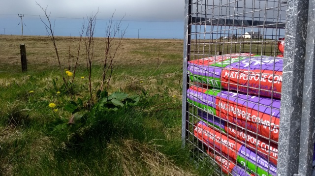
West Kilbride also has a craft shop, set in an old and verdant walled garden. The latter is private but the owners have kindly provided explanatory signage – the soil was enriched with eighteenth century Parisian sewage, carried as ballast in French sailing vessels and sold to Hebrideans as fertiliser. Soil enrichment is very much a thing on this next stage of the trail, as you will see and quite possibly smell.
Another feature of the South Uist section is that apart from a detour to a debatably attractive statue it’s more or less entirely flat. This makes, as the guidebook tells you, for easy walking. What the book doesn’t tell you is that as you turn northwards from West Kilbride the south-westerly hoolie literally drives you round the bend.
Luckily there was a bus shelter at Pollachar in which I was able to huddle while trying to work out that the ‘Machair Way’ signs were now sending me in what seemed to be the wrong direction. It turned out this was because I’d sleepily trudged up the road from Kilbride instead of taking the correct route out around the headland and past the Pollachar Inn. Evidently some instinct for psychological self-preservation had prevented me from having to contemplate a closed pub at seven am in the Outer Hebrides.
The little roofless chapel at Boisdale is a welcome shelter from the maddening wind and a great spot for breakfast.
In fact for hikers of a disrespectful bent who aren’t afeared of ghosties this place would make an excellent bivy, although personally I draw the line at putting a tent up in a graveyard.
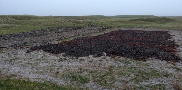
An odd landmark at Boisdale is a mysterious derelict-looking building surrounded by a high but collapsing security fence. Apparently this was intended to be a facility for the repair and/or recycling of salmon farm netting, set up back when salmon farming was the next big thing in the Outer Hebrides. Although there clearly is some successful pisciculture on the islands I saw far less than I expected and for some reason all the salmon in our Tesco is from Norway. Meanwhile, old salmon farm netting is now just dumped along the South Uist seashore, possibly with dune stabilisation as an excuse. Or possibly not.

Old fish farm nets merging into the beach environment.
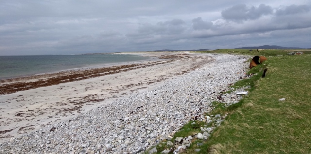
To my amazement and relief, as I trudged north towards Kilpheder the wind dropped somewhat. Released from my confinement of hat and hood I was able to take a more intelligent interest in my environment. This consisted of crofts to the right of me and to the left of me miles and miles of beach, all of it entirely covered in thousands and thousands of tons of stinky, rotting kelp.
Most people who’ve visited the Outer Hebrides go on about the beaches but I’m from North Norfolk where we have beaches and we don’t have kelp. Personally I take the perhaps controversial view that a beach without kelp is a superior visitor experience. However this is not a view shared by birds, great flocks of which were merrily foraging along the kelpy strand. In fact it was a pretty spectacular ornithological experience, and I’m from North Norfolk where we have birds.

The kelpy and bird-infested beach. This goes on for some considerable way.
Where the trail veers away from the kelpy beach, it takes you instead through kelpy crofts. To a man from Norfolk these are actually quite interesting.
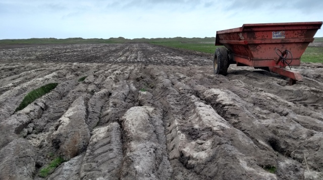
To East Anglian eyes crofting on South Uist seems an alarmingly haphazard and marginal kind of farming. Everywhere in early May the crofters are puttering about on their antediluvian tractors, tickling the sandy soil with tiny rusty ploughs that in Norfolk would be considered barely fit to hang on the wall in Ye Olde Village Gastropubbe. You can be walking through dunes or through what seem to be just grazing meadows when suddenly you’ll come across a small and completely random spud patch, ploughed up in the middle of nowhere and laboriously spread with stinking kelp from great overwintered heaps of the stuff.

The trail passes through typical South Uist crofts. These might at times seem a little uninteresting to walkers not either agronomically or ornithologically minded.
Seemingly random patches in the dunes are scratched with a shallow plough and spread with rotten kelp. This has been going on for hundreds, possibly thousands, of years here.
The crofts are also rich in birdlife; as well as waders I saw more Twite here in sixty minutes than I’d seen in the previous nearly sixty years. At more than one point the trail was a little confusing – navigating through working farms always seems to me much more difficult and stressful than walking a compass bearing across open uplands. The mystery pixies who waymark trails universally seem to like spoiling the wildest country with endless marker posts, while leaving you to face angry farmers, dogs, cattle and barbed wire in the lowlands without any clue as to where the right of way might be.
Although the crofting appeared anachronistic and in some places was clearly more of a hobby than a living, as I walked along I found it increasingly moving. Ultimately, I was almost moved to tears where a more modern plough had, perhaps inadvisably, turned the soil a little more deeply than usual. Just ten inches down it was pure silver-grey sand! I realised then how dearly and with desperate labour the brown top layer had been bought.
For centuries subsistence farmers, literally dirt-poor and including women and children, had dragged baskets of kelp from the beach; massive heavy baskets of the reeking stuff, borne on their own backs. No tractors, no quad bikes, in most cases not even a donkey. With just kelp, with the dung of a few animals (and I dare say their own) and with unimaginably hard labour people had created this shallow, brownish soil out of nothing.
Worse still, many of the people whose families had toiled to make this soil were then cruelly cleared off their treasured crofts to make way for more lucrative sheep grazing. I stood by myself in the wind in the middle of nowhere staring at some dirt. Suddenly I began to understand the passionate attachment of Hebrideans to crofting, both as a way of sustaining life and as a heritage.
I trudged on, voluntarily choosing to spend a few days with a heavy pack on my back, out in wind and weather but in my case with a credit card in a plastic bag. And safely in several bags a ticket home to Norfolk, where the rich soil is mostly owned by large agribusinesses, rights of way for walkers are strikingly few and nothing is grown that can be picked and eaten. Our miles of winter wheat, oilseed rape and sugar beet are just industrial raw materials for the processed foods that are killing us all. The profits, quite logically, go more to the investors who buy the huge machines than to the tiny number of hired hands who operate them.
Happily, the smell of rotting kelp has remained indelibly with me as a souvenir of a more humane and sustainable agriculture on South Uist.
Machair soil on South Uist – pure sand just a few inches down.
A little further north the kelp peters out and, to my astonishment, the sun peeped out. Stunned by this development I stopped out of the wind in the dunes. Lunch of cheesy pasta was made especially tasty by brackish cooking water scooped from a convenient rock pool.

The convenient rock pools of South Uist. That’s not my cooking pot, by the way.
‘Do you think the sun will stay out for a bit now?’ I asked a local dog walker. ‘Well now,’ he replied. ‘You see that mist, on those hills? That’s a bad sign’.
Further north, the kelp on the beach peters out somewhat. However it turned out I wasn’t supposed to be walking along this relatively unkelpy beach.
Past the golf course at the track to Kildonan the trail becomes a bit confusing. I carried on walking up the edge of the beach but this isn’t the official route. You’re supposed to head inland, which means picking your way through yet more crofts and their numerous fences. Sleepily, I then followed the shoreline without keeping tabs on my bearing and ended up halfway out along Rubha Àird a’ Mhuile, the westernmost point of South Uist. By this point in the day, the walk back to Tobha Bhornais and along the track past Loch Toronais seemed rather tedious.
The road from Stoneybridge brings herds of camper vans to the shore at Cnoca Breac and I was glad of a bit of company and chat along here. Approaching Howmore there’s excellent wild camping by the river near the bridge. If you get there late in the day you might be glad of this as the hostel is quite small and doesn’t take bookings although you can camp and use its facilities for a contribution to the funds of this small and very worthwhile charity. Another invisible Corncrake was craking away in the meadow as I approached the village.
I’d arrived by mid-afternoon so as my laundry and wet tent dried quickly if somewhat hectically on the washing line, I very much enjoyed several mugs of the tea that’s included in the very fair price. Not only that, I got lucky with the ‘free food’ box in which previous kind hostellers had left bread, breakfast cereal and numerous tins. A warm, dry bed in a warm, dry room; a hot shower; tea, coffee and milk in a proper kitchen; a common room you can stand up in; friendly company; two free meals, and all for £16!
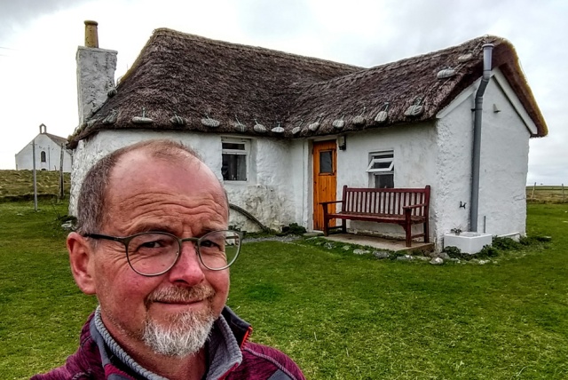
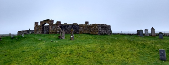
A night in the lovely Gatliff Trust hostel at Howmore is a must. It’s on the trail and you get to sleep in an actual blackhouse.

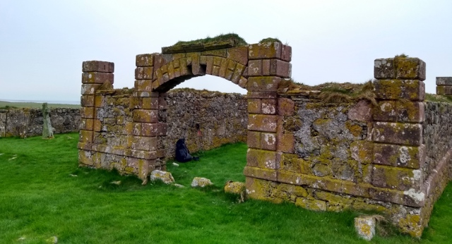
Also the ruined chapels next to the hostel at are interesting and atmospheric.
After scrounging more free food for breakfast I was sorry to leave the cosy common room, with its typical Hebridean decor of cycling shorts.
Day Three – Howmore to Shell Bay (Benbecula), about 25 km.
North of Howmore the trail takes you away from the kelpy, beachy side of South Uist and shows you another side of the island – the squelchy, peaty side. To immerse you properly (and in places literally) in this aspect of the terrain considerable effort and expense have been invested to allow walkers to traverse one very boggy side of a triangle. The second side of this is the B890 and the third (unwalked unless desperate) side is the A865. If the weather really is desperate and there’s no view at all I’d consider walking up the A865, although it can be quite busy.
Not that the official route is hard going. It’s completely flat and there are some impressive boardwalks and even a smart footbridge, the first of many such on the subsequent trail.

This nameplate is perhaps either Uistian dry humour or one of a series of elementary English lessons for Gaelic speakers.

Thank goodness for EU-funded boardwalks. Without them in these South Uist bogs a grown man on horseback could disappear without trace.
Where the trail joins the B890 a small lekking ground has thoughtfully been provided for free range camper vans to competitively display their ornamentation of kayaks, satellite dishes, mountain bikes, etc. to each other. It’s important these large, powerful creatures are allowed to express their natural behaviour in the wild.

You see that mist, on those hills? That’s a bad sign.

Approaching the A 865, an ecological case study. Left: with sheep. Right: without sheep.
As I walked up the A865 towards Gerinish I was joined on the carriageway by a large dog that appeared out of nowhere. A dog somewhat wolfish in its size and general aspect. It frisked alongside me, in the middle of the busy A road. Local drivers grinned and waved. Tourists in camper vans and hire cars slammed their brakes on and looked aghast.
I cried ‘shoo, go home’ at the demented creature and it ran off ahead of me, down the middle of the road towards a blind summit, leaping up and barking playfully at passing vehicles. Passing at fifty miles an hour, that is. Having once seen a large German Shepherd hit by a van when it ran into a road I was walking along, I was braced for the worst as I crested the hill, but there was no sign of the bonkers beast. Hebridean hounds must have more lives than cats.
Here, for the sole time on South Uist, the trail treats us to a little climb in order to admire the extensive views. We’re also supposed to admire (fanfare…) Our Lady of the Isles, a devotional sculpture funded by public subscription. The Scots are fond of their monuments and when I carelessly observed on Facebook that this reminded me of something North Korean I was firmly informed that it was in fact sculpted by a chap from Fife and is considered a notable exemplar of the Scottish Arts and Crafts Style. So there we are. ‘My Dad brought the stone for that in his Post Office van’, a Hebridean IT consultant told me, pointedly.
Provenance, genealogy and communal labour are still important to Gaels in a way English people struggle to understand. Anything a relative had a hand in building becomes part of your family narrative, irrespective of its overt function or symbolism and of who claims to ‘own’ the land it stands on. Also, to be fair, North Korean statuary has its fans.

Our Lady of the Isles enjoys her extensive views.
After this slightly bizarre diversion, we head off again into the bogs, where we encounter something that to me is much more interesting and authentically Hebridean – our first example of a raised turf path. With this example, it is occasionally necessary to use the words ‘raised’ and ‘path’ very, very loosely.

Some sections of the raised turf path are more raised than others.
Some sections have been improved with plastic mesh.

To be fair, other sections are jolly nice and dry. Almost all of the South Uist stage of the Hebridean Way is pretty easy going and generously waymarked.
After the turf path comes a moorland section which at first seems quite excessively waymarked. After a while you become very glad of the numerous posts as taking short cuts between them, rather than sticking to the marked and occasionally counter-intuitive route, can result in wet shins and even wet knees. You’ve already got wet feet.
Eventually another smart boardwalk leads up to one of three full-size wind turbines. This is quite something as rarely anywhere else will you get the chance to stand right at the base of one of these impressive monsters.

Hebridean reels gave some lunch break shelter from the persistent cold wind.

The concrete bases of the towers came from Germany. To the Outer Hebrides.
The wind turbines are interesting not just in themselves but because they’re owned and run for public benefit by a community trust. At their base I met a sometime BBC wildlife cameraman (recognisable as such by his expensive Mountain Equipment apparel) who’d been hired by the trust to make a PR film about them – I can imagine their appearance in this scenic location hasn’t universally been welcomed. As we chatted, the sun came out. He got some decent light, I got some relief from the chilling wind.
After the dry, firm hike down from the turbines the trail then treats us to another 800 metres of bog, culminating in a small but perfectly formed swamp. On the far side of this hazard is an alluring path up to a gate. A path, in fact, that does an excellent impression of a hiking trail. Instinctively all experienced British trail walkers will head uphill to this gate, assuming from bitter experience that trail sections always culminate in comedy swamps.
Strangely, once through the gate they’ll find themselves in what seems to be somebody’s garden. Even more oddly, they will then find themselves walking with increasing disquiet down what is definitely somebody’s private driveway. Don’t go through the swamp and then the gate! Bear left down the slope to Ardmore instead.

Restored blackhouse at Ardmore. When the sun comes out, the Hebrides are quite colourful!
Returning to the A865 one has a choice of supermarkets. At the South Uist end, the appealingly independent Lovats has a great range of provisions as well as hot drinks and a Post Office. It was necessary for me to eat quite a large second lunch here, although I had to sit on a sheltered rubble heap to do so comfortably as their picnic table was located right in the teeth of the implacable cold wind.

I wasn’t entirely convinced of the authenticity of my Hebridean lunch at Lovats although the rubble heap added atmosphere. Why the marketing gurus at (or possibly on) Mars decided in 2018 to write ‘broken’ on Snickers bars only they can tell you.
Lovats had temporarily sold out of local convenience foods so my lunch consisted entirely of things I could buy at home. What I don’t understand is how Ginsters can make a chicken and bacon slice in distant Cornwall which can then retail for ONE POUND in the Outer Hebrides! Perhaps a Celtic pasty mafia distributes them very cheaply via a network of slice mules? Perhaps they’re floated around Wales and up the Minch on gigantic pasty pontoons? My mind boggled as I squatted on my sunny rubble heap, with an extensive view of some compost bags.
Meanwhile one of the thinnest, oldest ladies I’ve ever seen walked into the shop slowly but independently. Speaking only Gaelic, she spent a happy hour or so buying about six items. Endearingly, as I watched from my rubbly observation post, at least half a dozen other customers offered her lifts home, one of which she graciously accepted with what sounded like a quiet, unpretentious blessing.
For centuries Hebrideans turned sand into fragile soil with creels of kelp and backbreaking labour. Now they just buy three bags of compost for a tenner, like the rest of us.
As I ventured onto the causeway the sun came out properly! Finally, as I stepped onto Benbecula, I acquired my first calendar photos of the legendary but so far elusive Hebridean clear waters and white sands.

From the causeway to Benbecula. Isn’t this how the Hebrides are supposed to look?
At Creagorry there’s a splendid Co-Op, at which, it may come as no surprise to hear, it was necessary for me to eat a third lunch including a pie actually made on Benbecula. Prices in here were no different from Co-Ops in rural Norfolk and much of the merchandise was identical. However there was a minor frenzy around the reduced items, where I discovered locals filling their baskets with yellow stickered packets of Hebridean ‘cocktail crab claws’, caught and packed just down the road but normally very expensive. I bagged a pack myself as I wanted to eat something local and I fancied they would go well in my Supernoodles later on.
While walking trails in Scotland and the north of England, I’ve been repeatedly struck by how vital the Co-Op supermarkets are to many small towns away from major conurbations. In the Hebrides I also noticed they have an enlightened policy of allowing community shops on smaller islands to stock their branded goods. Impressive, and worth supporting.
I popped into the Puffin Studios craft shop too, making clear I was just being nosey and wasn’t about to fill my backpack with crafts, nice and unusually well-chosen though they were. When I explained about the trail and the walk past the windfarm, the lady said well, that was funny. Her neighbour at Ardmore had been telling her just the other day that he really can’t understand why people with rucksacks keep coming into his garden and walking down his drive. ‘Ah’.
At Liniclate I was faced with three confusing options. The LDWA GPX points sent me off the road as soon as possible. The Cicerone guide sent me off it a little further along. Neither were correct, according to an agitated gentleman who came rushing out of his bungalow in what looked like his pyjamas as I stood scratching my head over the non-existence of access to the beach at the correct grid reference. ‘It’s further on’, he insisted, bafflingly, ‘further on. Everybody stops here, but your trail goes down the far side of the hotel. I’m going to write to the Nature Conservancy about it. Look – ‘.
He grabbed my arm, not unkindly, and pointed me towards the Dark Island Hotel. I humoured him and headed off along the pavement, thinking I’d probably have to turn back but, no, he was absolutely right, the trail signs did point down the far side of the hotel. They then sent me in something of a dogleg direction back towards the dunes after, not before, the wind turbine.

I’d carry on along the pavement until you come to a sign. Obviously I can’t guarantee the bizarrely blue sky. The trail passes the hotel entrance, at which the temptation to call in for a pint may be overwhelming.

Finally a bit of sunshine at Shell Bay, Benbecula. South Uist behind. That mist is only temporarily clear of those hills.
The trail had been waymarked through the dunes around the south-west corner of Benbecula, but the south-west corner of Benbecula takes a bit of a beating in winter. Consequently many of the wayposts were already a bit wonky and quite a few were teetering on the very edge of dunes already eroded by winter gales.
I had a look at the beach, then ventured back inland to the campsite in hope of a bit of shelter from what, despite the sunshine, was still an aggravatingly persistent, strong and cold wind. Disappointingly, the site was quite exposed but in the course of a brief conversation it became apparent the proprietors are so nice (and the pub so alluringly close) that it would have been criminal not to stop there.

I took a few photos of the sunshine in case I never saw it again.

Ditto the blue sky.

Looking from the beach the red-roofed white building is the campsite facilities block. You need to follow this track round to the left of the grey bungalow, which is the owners’ house where you check in.
I was just brewing up my crabby noodles in the laundry room (the only place other than the toilets where you can get out of the wind) when the lady owner came in to check her drying. I apologised for any fishy smells and she explained in which bin outside I should please deposit my crabby packet, looking at me slightly askance the while as if she feared I might keel over from exhaustion and wind fatigue at any moment. Did I have hot water to make a cup of tea, she then enquired, in a concerned tone.
When I lamely explained that I didn’t even have any tea she said firmly in that case she would make me a cup and bring it over. It came with a little foil lid, accompanied by a baby Twix and a French Fancy in a little foil parcel. Did I mention they’re nice people? Camp there you must, it’s only eight quid and the showers are great. Obviously I can’t guarantee the French Fancy but looking pathetic goes a long way in the Outer Hebrides. Which was lucky as that’s one of my core skills.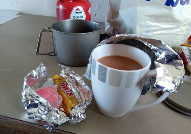 And if I were you I wouldn’t bother the hassle of making crabby noodles either, because the food in the Dark Island Hotel looked awesome. Even fellow-hikers were failing to finish the vast portions. It was self-evidently necessary for me to order a fifth lunch of cheesy chips but even I struggled a bit to do justice to the calorie mountain I was presented with. The ‘draught’ beer was scotch fizz but they had Orkney Ales in bottles. I enjoyed a couple of the latter very much, while musing that if a fortune teller had once said ‘some day this boy will eat a French Fancy on Benbecula’ I doubt my parents would have crossed her palm with much silver.
Day Four, Shell Bay to Carinish (North Uist), about 27 km.
Very few photos exist of this day, it was so blooming awful I hardly dared get my phone out of its trusty sandwich bag. The wind dropped a little overnight so I did get some sleep, but I was awoken around six by the patter of rain on the flysheet. One look outside told me that things were absolutely NOT going to get any better anytime soon. I whipped the tent down in minutes and flung everything into the shower block, festooning the entire place with camping gear while I showered and cooked up porridge and cocoa.

I tried to avoid making animal noises while enjoying my breakfast cocoa, as the rain hammered on the roof of the toilet block.
Stuffing drybags into carrier bags and battening down my backpack I stepped out into the downpour. It was awful. Along most of the kelpy beach between Borgh and Baile nan Cailleach there was clearly a conflict between the trail and a crofter as new fencing, much of it electric but thankfully not live, had pushed the croft boundary right to the edge of the dunes while many of the trail markers within the said dunes had again been displaced by winter erosion. I ended up walking on the beach.
At Peighinn Lodain I obediently followed the trail signs along a lane perpendicular to the beach, then faced a baffling backwards trudge all round Aird and along the road. I should have used my compass and taken the short cut, as shown in the Cicerone guide. The slog up the hill towards the A865 was filthy; it was 8 am, parents driving kids to school in warm, waterproof cars stared at me in amazement as I trudged through the horizontal rain past their neat, waterproof houses. The only few minutes of slight relief from the hoolie were gained in the lee of the water works at Loch nam Faileann.
Crossing the main road, the trail takes you past the waste transfer station and through the landfill site in preparation for the ascent of Ruabhal (124 metres), which is particularly famous for extensive views. Or, more likely on this day, for hikers being picked up like pieces of trash and flung into Loch Olabhat, the hoolie of the day having a distinctly south-easterly origin.
Hang on, this was actually good news. It meant that on the climb up Ruabhal I’d be in the lee of the hill. Oh joy! I quickened my steps towards the said hummock which, despite its modest height is surprisingly imposing in its setting. Sure, enough, the ascent was quite benign, so much so that halfway up I stopped and had a few snacks out of the wind.
I was a good thing I’d Snickers-stiffened my sinews because conditions at the top were ha-ha-ha hilarious, I could ha-ha-hardly stand up, even with poles. Manfully I took record shots of the views, which were extensive but strangely similar in all directions, especially in the matter of cloudiness. My phone battery ran out.


The rain had paused by this point but the wind was troublesome.
I should really have gone into Balivanich for a proper hot breakfast. It’s only a kilometre each way from the trail but in teeming rain and strong wind the thought of adding a whole two thousand paces to the day’s labour was heartbreaking. Other than in Balivanich there was absolutely nothing to eat or drink on this section other than what I could carry.
The wind being south-easterly it was pretty much perpendicular to the causeway onto Grimsay, which carries a busy single track road. Large quarry trucks were a particular hazard, shuttling busily between some building project on Benbecula and a quarry at the North Uist end of the causeway. Had it not been for my walking poles I think I would have been in serious danger of getting blown under a vehicle.
I was subsequently told that in winter pedestrians have been blown off this causeway and drowned, possibly an apocryphal tale but one I’m inclined to believe after my own experience. I huddled in the bus shelter on Grimsay to eat another Snickers bar. A cyclist coming south didn’t need to use his brakes to stop and chat. Well, to shout. He elected to get off and walk along the long causeway for fear of being blown over.
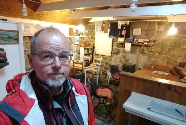
By the time I got to Moorcroft Holidays I was windblown to distraction and all I could think about was finding somewhere to sleep indoors. After one look at me, the friendly cleaner led me to the campers’ kitchen and made me a mug of tea. This softened only slightly the heartbreaking news that the bunkhouse was fully booked. ‘There is,’ she mused, barely audible above the roaring of the wind around the steel roof, ‘a Hobbit House. But they’re fifty pounds a night.’

My pricey but rather splendid Hobbit House.
I knew instantly that I would gladly have paid even fifty pounds to impersonate a Hobbit on that particular night, but a hiker’s haggling instinct dies hard and in response to my cheeky enquiry she kindly offered to call the owner and ask about a single occupancy discount. Forty quid, the reply came back, but she’d have to clean it first.
As the rain lashed and battered the kitchen roof so hard I could hardly hear myself think, I ate Babybels and oatcakes and drank more hot tea in celebration of my imminent translocation to the North Uist Shire. Quite a lot more hot tea. So much tea in fact that I needed to venture out to the loo, where out of sheer reluctance to step outdoors again I spent quite a time studying the impressively wide range of local information provided. When I did poke my head outside again, incredibly, the rain had stopped and the sun was out!

My view of the North Uist Shire
This was a temporary aberration. It variously blew and poured again for much of the night. A friend comfortingly told me on Facebook that ‘our brand new tent was completely ripped to shreds on North Uist’. In the morning a latecomer’s tent, pitched in the only sheltered spot behind the kitchen building, was soaked as if it had been hosed and was hanging in disheveled baggy drapes. Pegs had failed to stay pegged; the occupants had escaped through storm and darkness to huddle damply in the kitchen.
But I must say I spent a very happy night in my Hobbit House, particularly as I’d been delaying trying my packet of freeze-dried Summit to Eat chocolate mousse until an actual catering emergency. I wasn’t too sure about the concept of freeze-dried mousse, let alone its execution. To my astonishment it was absolutely delicious.

Seriously, freeze-dried chocolate mousse. Astonishingly good. I’d buy it to eat at home.
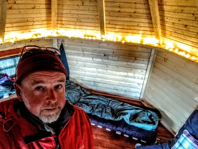
More Red Dwarf than Hobbit…


What a wonderful account of your travels. I certainly got a feel for the weather!
LikeLiked by 1 person
Thank you, and sorry about that 😉
LikeLike
I now feel rather ashamed of myself, having just returned from a month on the Outer Hebrides in our tin shed (motorhome), in which not only did we have warmth, dry shelter, a shower and sustenance, but we also enjoyed only 2 days of rain in 32 nights! Sorry about that!
Your style of writing is great and you’ve captured the feel of the place and people so well.
LikeLiked by 1 person
Thank you so much for visiting and for this kind encouragement. Ha ha, yes, after I left the Outer Hebrides the weather very much improved! I was absurdly lucky with the weather on the Scottish National Trail last year, so must have deserved a bit of rain this year 😉
LikeLike
Hi Andrew, like I did on the Scottish National Trail, I am reading your Hebridean Way blog posts as I walk it. i just read this section as I am about to venture out to do the same part on what is going to be a relentlessly rainy day through bog!
LikeLike