
In 2017 I walked the entire length of a nation. Apart from a couple of minor snags it was surprisingly straightforward…

The SNT is nowhere waymarked, three of these plaques are the only evidence on the ground of its existence. I haven’t quite mastered the art of the selfie, what a silly expression!
This trail is long but manageable and almost overwhelmingly interesting. In fact I’m still reeling from all I saw, how much I learnt and how it’s broadened my horizons. The first part of this post outlines the basic practicalities of hiking from Kirk Yetholm to Cape Wrath, around 470 miles. The second half is a summary of my itinerary. Jump to it by clicking here.

Adapting to local resources…
The Scottish National Trail was mashed up from sections of other trails by Cameron McNeish. His coffee table book Scotland End to End narrates his pathfinding walk along it, in his usual colourful, enthusiastic style.
This book isn’t a trail guide but a souvenir, readable and entertaining with great photographs, although it could do with a few more of the latter and their print quality isn’t great. I hope McNeish gets a chance to tidy the book a little for a second edition, it reads as if it was finished in a slight hurry and the ‘directions’ are a bit redundant as you’d never carry such a bulky tome in your rucksack. You’ll want this book as a keepsake once you’ve walked the trail, but it isn’t your primary source of information for planning.
More practical and in fact the sine qua non enabling resource for the Scottish National Trail is the Walk Highlands website, which provides mapping, directions and downloadable GPX files. For each day I made a laminate of their directions (heavily edited) augmented with notes, stripmaps and details of tricky looking bits. The Walkhighlands route differs in a couple of places from the route in McNeish’s book but their directions worked perfectly for me, a Scottish hiking newbie.
Laminates are heavy so I posted a bunch ahead and threw each day’s sheet away as I went; a bit heartbreaking after the work I put into them. As I moved onto the Cape Wrath Trail, for which I had a guidebook, my laminates became sparser with 3-4 days on each sheet.
The GPX files were 100% reliable and quickly became my default navigation resource. I used them in the free mapping app OsmAnd, paying about two quid for the contour lines plugin which was invaluable. Lazily, I ended up not bothering with paper maps at all, which is not really the done thing in such remote country.

Phone screenshot showing the GPX waypoints from WalkHighlands imported into OsmAnd. This is the Falls of Glomach, where I was particularly glad of being shown the way. I found OsmAnd completely reliable, it needs no phone signal and is virtually free, the contour lines plugin cost £2.09, I think. Set it to store its maps on your SD card before you download them, as they’re huge files.
In my defence, the Scottish National Trail is not Munro-bagging but a very long scenic walk through glens, over the odd bealach, along forestry trails, canals and rivers. There are only two summits, one at the start and one at the end.
After my battery issues in Wales I’d invested in a new Moto G5 phone which gave me three days’ battery life in airplane mode with Android Battery Saver. This was my camera as well as my phone and Internet and I carried a spare battery. Why people carry separate GPS’s and cameras when a smartphone does the lot is beyond me.
I must admit there were days when my phone got worryingly wet. My ‘waterproof’ case leaked after a week and I ended up using sandwich bags as usual. Another time I’d consider a more water resistant phone, although the advantage of the Moto G5 is that it’s dual SIM, so pretty much anywhere other than Cape Wrath and Bynack Lodge you’ve a chance of signal on one side of a hill or the other.
Obviously I carried a compass and whistle and in the most remote sections I had Plan B’s (acquired from OS maps) noted on my laminates. I’d have liked to carry OS maps for context and flexibility, but the expense and logistics of acquiring all the maps for the 470 mile trail were prohibitive.
I posted ahead a copy of Iain Harper’s Cicerone Guide Walking the Cape Wrath Trail, mainly for the useful maps. For the SNT you can throw the first third of this book away, you don’t join it until page 71. With hindsight I might have bought the Harvey CWT maps instead, for their wider context. You don’t really need the book directions if you have the Walk Highlands directions, but then you don’t have to spend days editing the book as it’s already pretty terse.
If I was doing a quick, ultralight Cape Wrath Trail starting from Fort William now, I’d probably just carry the book, a compass and my phone with the GPX files. But that’s easy for me to say, I know the way. Maps give a better understanding of the landscape and you don’t have to keep asking other walkers ‘what’s that mountain?’ and ‘is that the sea?’ Too much information is better than too little, especially as the CWT passes through remote country, much of it rough and trackless, and none of it is waymarked. Personally I hope it stays like that.
The WalkHighlands directions were almost 100% reliable, and at least one of the very few typos I found has since been corrected. Several discouraging trail reports had me worried, but I found they bore no resemblance to conditions on the ground. For example in Glengarry hikers reported hard terrain and impossible river crossings. In fact now you just follow a new bulldozed forestry trail all the way to Garrygualach, where there’s a smart new bridge over the previously difficult burn. I see that now (June 2017) these directions have been updated and misleading reports removed which is impressive and reassuring.

New bridge at Garrygualach (May 2017)
On the downside, the original WalkHighlands directions are far too wordy for practical use on the trail. I had to spend a long time editing them into a concise format suitable for laminating. I’ve raised this with them but they’re unrepentant, and they don’t want me to make my edited version available to you, sorry. Still, they’re a great resource that must have taken a lot of effort to create, they’re actively maintained and are provided free of charge, so ‘thank you WalkHighlands’.

Ice inside tent!
Ideally you want to reach the Highlands in mid-May before the midges, but the SNT is a long hike and spring is cold in Scotland especially at night, so your time window for lightweight backpacking is short. I set out on April 11th and was at Cape Wrath on May 18th just as the first few midges were emerging. I was exceptionally lucky with the weather but I still had to trudge through snowstorms and on more than one morning I awoke in a tent full of ice.
To camp in Scotland in April even on a low-level trail like this you need to be equipped for sleeping out at zero Celsius, or in my case as I sleep very cold, somewhat below.
There are also sections of this trail where you need to carry non-trivial amounts of food. Twice my plan showed I needed to carry eleven meals and once eight meals. I allow 250g of dry food per meal, so that was up to 2.75kg extra pack weight.
To hike 450-odd miles in one go you must from the outset commit to walking light and nimble. My base pack weight was about 10 kg including waterproofs, tent and a three season synthetic sleeping bag. My pack was a 600g vintage GoLite bought for £48 on eBay. Contrary to advice in guidebooks I wouldn’t consider walking this trail in heavy boots. Boots are good for climbing Munros but this is long distance trailwalking, a completely different kettle of feet.
Most people I met on the Cape Wrath Trail walking in traditional boots had blister – some had shocking open wounds. Some were also deeply fatigued from lugging packs of twenty kilos or even more, with an additional kilo of permanently wet leather dragging on the end of each leg. Meanwhile, as heavily-booted hikers despaired of their foot rot and in several cases gave up, I skipped along for 450 miles like an irritating pixy in my Salomon X-Ultra Prime mesh shoes, the burn water flowing through them keeping my feet cool and clean. On cold rainy days and on long stretches of boggy ground I wore Sealskinz waterproof socks.

Mesh shoes are what you want for wading rivers. This is the dreaded Garbh Allt at the north end of the Cape Wrath Trail. On this day it was a pussycat, I paddled around in it just for fun. Two days later after heavy rain it was impassable. Scottish rivers are like that, which is why you carry a tent, and have ‘spare day’ in your schedule.
When I got to Cape Wrath these shoes had worn out, but by then they’d done over seven hundred miles of rough trail walking and I’ve just bought replacements for seventy quid. Although the shoes were worn in, a full pack changes your gait and I did have minor blisters on my little toes in the first week; I just broke out the Compeed and carried on.
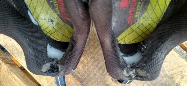
Oh dear, poor things, 700 miles on the clock. Those Sorbothane insoles have had it too, but then they’ve done well over a thousand miles including two Pennine Ways and the SNT.
I followed the same basic pattern as on the Pennine Way, four or five nights of camping then a hostel or BnB to shower, wash clothes and dry out. My income is modest so camping was essential, mostly wild camping not just to save money but because I keep hikers’ hours and sleep better in peace and quiet. The most I paid for a BnB was £50, but that was a more like a country hotel and well worth it, especially as it snowed heavily that night and the breakfast was vast and delicious. Hostels were around £18-£25.
Generally BnBs were excellent value and the hostels were great too, although a couple were more geared to trendy youths on coaches than filthy trailwalkers with wet tents. Above all, Scottish people were universally kind and friendly; even in the most unlikely-looking towns I was amazed how they all seemed to have time for a stranger. Short holidays in Scotland have never been enough for this attitude to sink into a dour, suspicious Englishman but now after six weeks up there I think I’m something of a changed man!
Hardly anyone I met had heard of the Scottish National Trail and I didn’t meet or hear of anybody else trying the whole thing. As it takes an average walker five weeks (I allowed six) I suppose that’s not surprising. I was surprised how busy the West Highland Way was, even in early spring, and relieved that the SNT only spends a single day on that very popular trail before diverting onto the quieter Rob Roy Way.
Otherwise, it was only once I’d reached the Cape Wrath Trail that I started to meet and mingle with other through-hikers as I’d done on the Pennine Way. Unlike on the PW, though, most were from overseas. Elsewhere, I walked through endless miles of exceedingly remote landscape without encountering another soul.
It was obvious that long sections of the trail would normally be much, much wetter. Apart from some very cold nights, a few dreich days and a spot of bad luck with snowmelt in the Cairngorms, my biggest problem weatherwise was sunburn!
Here’s my full itinerary, both planned and actual.
I walked the Scottish National Trail (most of it) in 37 days, of which four were rest days and the last three an eccentrically slow amble over Cape Wrath. As it turned out I could have come home a week sooner, but other than in the Cairngorms I was exceptionally lucky with the weather. This trail would be harder and slower in normal conditions.
I planned around a rough average of 30 km a day, being less ambitious on what sounded like tougher sections. I’ve left in this itinerary my original notes on food. The first week’s schedule was constrained by accommodation bookings made long in advance. I’d done this because it was Easter, so I’d figured everywhere would be very busy. In fact I could, and should, have been more flexible.

Not Scotland but North Norfolk, dawn on the way to Sheringham station. In order to get to KY in the early afternoon, I pushed through woods and stumbled along clifftops in pitch darkness. Then the train broke down anyway. Always have flexibility in your schedule if trains are involved!
Day 1, April 10th. By train to Berwick on Tweed. PLAN: Bus to Kirk Yetholm via Kelso. Walk 10 km to Morebattle. Supper Templehall Hotel Morebattle. Wild camp somewhere west of Morebattle. ACTUAL: I missed the last bus to KY as my train was three hours late into Berwick, hence I had to stay at Kelso. I’ll never be able to claim I walked the entire Scottish National Trail! (PS I subsequently walked this section in 2018).

The River Tweed at Kelso. The tall house with the chimneys is the BnB, actually a small and beautiful country hotel aimed at salmon fishing types where, having missed the last bus to KY, I got a last minute room online for £40.
Day 2, April 11th. PLAN: Morebattle – St Boswell’s ~ 32 km. Lunch Harestanes Visitor Centre,wild camp by Tweed opposite Dryburgh Abbey. ACTUAL: I got the Hawick bus from Kelso, picked up the trail at Crailing and wild camped in the Eildon Hills, which were blooming breezy.

The River Tweed on the St Cuthberts Way, Eildons behind.
Day 3, April 12th. PLAN: St Boswell’s – Brown Knowe via Melrose 28 km. Breakfast at Melrose and BUY 3 MEALS 0.75 kg. Wild camp on Brown Knowe 55.581, -2.975. ACTUAL: I wild camped in a more sheltered spot on the Southern Upland Way, lower down and somewhat past Brown Knowe which was very exposed in a freezing wind.

The Three Brethren, on the Southern Upland Way, Eildons behind.
Day 4, April 13th. PLAN: Brown Knowe to Peebles via Traquair 26 km. Lunch Cardrona village shop. Camp at Rosetta Holiday Park near Peebles. ACTUAL: a long and lavish breakfast at Cardrona, then as plan.

Peebles
Day 5, April 14th. PLAN: Peebles to the Bore Stane 30 km. Via shops at West Linton and supper at Carlops (Allan Ramsay Hotel). Wild camp near the Bore Stane. ACTUAL: as plan, except that the pub was too posh for supper, they charged me eight quid for a ham sandwich! Supernoodles for me.

Wild camped by the Bore Stane, a perfect sheltered site but another cold night.
Day 6, April 15th. PLAN: Bore Stane to Ratho, 27 km. Via Balerno (shops BUY 3 MEALS .75 kg) and Slateford. Camp at Linwater Caravan Park. ACTUAL: as plan, an easy day with two lavish meals.

Union Canal near Ratho
Day 7, April 16th (Easter Sunday). PLAN: Ratho to Falkirk via Linlithgow 34 km. Lunch at Linlithgow. Rosie’s Bed & Breakfast, 115 Oswald St, Falkirk. ACTUAL: as plan and very easy.

Falkirk Tunnel
Day 8: April 17th. PLAN: Falkirk – Twechar 21 km. Camp at Spotty Dog Campsite, Twechar. ACTUAL: as plan. This campsite was minimal, to say the least.

Frosty morning at Twechar
Day 9: April 18th. PLAN: Twechar – Milngavie 18 km then bus or train into Glasgow to stay with friends. ACTUAL: after breakfast at Kirkintillloch McDonalds I just carried on along the towpath right into the centre of Glasgow, which was easy walking and very interesting.

On the way into Glasgow
Day 10: April 19th. Day off in Glasgow, very nice too.

Glasgow School of Art
Day 11: April 20th. PLAN: Glasgow to Muir Park Reservoir via bus/train to Milngavie and supper at Drymen (pub 19 km) 24 km. Wild camp near Muir Park reservoir. ACTUAL: I had lunch at the Beech Tree Inn, bought pies at Drymen and camped in a more sheltered site beyond the reservoir, which is exposed and boggy.

Another totally obscure campsite!
Day 12: April 21st. PLAN: Muir Park Reservoir to Callander via Aberfoyle (lunch and BUY 2 MEALS 0.5 kg) 29 km. Wild camp somewhere outside Callander. ACTUAL: as plan.

Between Aberfoyle and Callander things finally start to look quite Scottish.
Day 13: April 22nd. PLAN: Callander to Comrie 27 km. Chippie at Comrie. BUY 5 MEALS 1.25 kg. Wild camp outside Comrie. ACTUAL: Starting to find these days fairly easy, I camped quite a way past Comrie.
Day 14: April 23rd. PLAN: Comrie to Loch Freuchie 30 km. No facilities. Wild camp at Loch Freuchie. ACTUAL: Loch Freuchie is sheep country with nowhere polite to camp, so instead I camped in a wood further on.
Day 15: April 24th. PLAN: Loch Freuchie to Aberfeldy 20 km. BnB at Aberfeldy, Balnearn House, Crieff Road, PH15 2BJ. ACTUAL: as plan, and very nice too, superb breakfast.
Day 16: April 25th. PLAN: Aberfeldy to Blair Atholl via Pitlochry (lunch). 29 km. Camp at Blair Atholl or Bridge of Tilt. ACTUAL: At Aberfeldy it started to snow and the forecast for the next night was extremely cold, consequently I cut this day short and booked myself into the excellent SYHA Hostel at Pitlochry for the night instead.
Day 17: April 26th. PLAN: Rest day at Blair Atholl. BUY 8 MEALS 2 kg. ACTUAL: Pitlochry to quite a way up Glen Tilt, where I wild camped.
Day 18: April 27th. PLAN: Blair Atholl to Bynack 27 km no facilities. Wild camp near Bynack. ACTUAL: I walked up Glen Tilt in continuous heavy rain to Bynack Lodge where unfortunately due to the rain and snowmelt I couldn’t get across the Bynack Burn. Being alone and lacking experience to judge when the rivers might fall again I turned back towards Blair and ended up wild camping again back in Glen Tilt.

Not a river, this is the path!
Day 19: April 28th. PLAN: Bynack to Glen Feshie, 21 km, no facilities. Wild camp or bothy at Glen Feshie. ACTUAL: I trudged and hitched back down Glen Tilt and got the train to Kingussie where with slight difficulty I found a BnB room.

BnB after two nights in the Cairngorms.
Day 20: April 29th. PLAN: Glen Feshie to Kingussie, 24 km. BUY 7 MEALS 1.75 kg. BnB at Kingussie, Greystones, Acres Road, OH21 1LA. ACTUAL: a nice day off at Kingussie attending the Local History Festival. Greystones BnB is truly remarkable.

BnB after a nice day off at Kingussie!
Day 21: April 30th. PLAN: Kingussie to Laggan 24 km. Wild camp somewhere near Laggan. ACTUAL: Back on plan, in fact I camped quite a bit further up Strathspey.

Estate bothy in Glen Banchor, East Highland Way.
Day 22: May 1st. PLAN: Laggan to Blackburn of Corrieyairack ~ 35 km. Bothy at Blackburn of Corrieyairack NH 3817 0289. ACTUAL: as plan, except that having walked more like 35 km the day before I was at the bothy by 2 pm!

Blackburn of Corrieyairack bothy.
Day 23: May 2nd. PLAN: Bothy- Fort Augustus ~ 5 km. BUY 11 MEALS 2.75 kg. Hostel at Fort Augustus, Morag’s Lodge, Loch Ness, Bunoich Brae, Fort Augustus PH32 4DG. ACTUAL: this planned rest day at Fort Augustus ended up coming rather soon after the unplanned rest on day 20.

Loch Ness at Fort Augustus
Day 24: May 3rd. PLAN: Fort Augustus to Allt Ladaidh via Mandally 28 km. Wild camp in forest near Allt Ladaidh grid reference 230 003. ACTUAL: Glen Garry is hopeless for camping due to the tree felling. I was lucky to find a pitch eventually at Garrygualach, a long day!

A tiny scrap of flat ground among the forestry at Garrygualach. An Osprey is fishing behind.
Day 25: May 4th. PLAN: Allt Ladaidh to Cluanie 29 km. Possibly Cluanie Inn for dinner. Wild camp past Cluanie. ACTUAL: arriving at the friendly Cluanie Inn well ahead of plan I used their WiFi to book a bed at the amazing Alltbeithe Youth Hostel.

Approaching the remarkable hostel at Alltbeithe (Glen Affric).
Day 26: May 5th. PLAN: Cluanie to Morvich, 26 km. Morvich Caravan Club site, Inverinate. ACTUAL: a nice short day from Alltbeithe along the Affric – Kintail Trail, I was at Morvich by 2 pm.

On the Affric – Kintail Trail west of Camban bothy.
Day 27: May 6th. PLAN: Morvich to Maol-bhuidhe, 23 km. No facilities. Bothy at Maol-bhuidhe. ACTUAL: as plan, surviving the long-dreaded Falls of Glomach.

One of the better bits of the path looking back to the Falls of Glomach. A head for heights is advantageous here, sadly I don’t have one!
Day 28: May 7th. PLAN: Maol-bhuidhe to Craig, 24 km. Gerry’s Hostel, Craig Achnashellach, Strathcarron. ACTUAL: as plan. Gerry’s is great!

The beautiful and isolated Loch Calavie
Day 29: May 8th. PLAN: Craig to Lochan Fada, 29 km. via Kinlochewe (17 km, shop) BUY 6 MEALS 1.5 kg.+ fuel. Wild camp at Lochan Fada. ACTUAL: as plan.

Wild camped at Lochan Fada, Slioch behind.
Day 30: May 9th. PLAN: Lochan Fada to Shenavall, 16 km, no facilities. Bothy at Shenavall. ACTUAL: as plan, the bothy was very busy.

Shenavall Bothy
Day 31: May 10th. PLAN: Shenavall to Clachan, 19 km. Dinner at Clachan. Booked TESCO DELIVERY, 11 MEALS at least 3 kg food total also gas/meths for stove. BnB 2 nights with dinner, Clachan Farmhouse, Clachan, Lochbroom. ACTUAL: as plan. Clachan farmhouse is lovely.

Towards Loch Broom from Clachan Kirk
Day 32: May 11th. PLAN and ACTUAL: Rest day at Clachan Farmhouse.

Looking back to Clachan from Inverlael forest, An Teallach behind.
Day 33: May 12th. PLAN: Clachan to Knockdamph 22 km. Knockdamph bothy (has stove). ACTUAL: I got to Knockdamph pretty early so pushed on to the Old Schoolhouse bothy which turned out to be much nicer.

Old Schoolhouse bothy at Duag Bridge
Day 34: May 13th. PLAN: Knockdamph bothy to Loch Ailsh, 27 km. Bar lunch at Oykel Bridge Hotel, wild camp at Loch Ailsh. ACTUAL: I was at Loch Ailsh by late morning. In a fit of madness, I pushed on all the way to Inchnadamph where having got lost and then jogged through pouring rain to beat competitors, I bagged the last bed in the excellent hostel.

Loch Ailsh
Day 35: May 14th. PLAN:Loch Ailsh to Glencoul bothy, 27 km. Bothy at Glencoul (fire). Push on to Glendhu + 6 km if supplies low, (fire). ACTUAL: I got even madder! A bloke at the hostel claimed heavy rain was forecast for May 15th and hence I’d never get across the Garbh Allt. Trying to beat the forecast rain, I yomped all the way from Inchnadamph to the River Laxford, around 40 km, phew!

Looking back, not without regret, at Glencoul bothy.
Day 36: May 15th. PLAN: Glencoul bothy to Loch a’Garbh, 30 km, very tough, no facilities. STILL MUST HAVE 4 MEALS, at least 1 kg of food. Wild camp at Loch a’Garbh. ACTUAL: Loch Stack to Sandwood Bay, where despite ominous skies the forecast rain still held off until the morning and I had the place to myself, not to mention a massive stock of food.

Sandwood Bay
Day 37: May 16th. PLAN: Loch a’Garbh to Sandwood Bay, 20 km. Via Badcall (shop, 10 km) lunch at shop and BUY 3 MEALS + treats, ~1 kg. Wild camp at Sandwood Bay. ACTUAL: being already at Sandwood Bay, I had a lie in as the forecast rain finally arrived, then strolled to the nearby bothy at Strathchailleach.

Strathchailleach Bothy, or Sandy’s House
Day 38: May 17th. PLAN: Sandwood Bay to Cape Wrath, 13 km. Ozone Cafe at Cape Wrath Lighthouse can provide informal accommodation. ACTUAL: Strathchailleach Bothy to Cape Wrath where I spent the day in warm sunshine and the night camped on the cliff top, supporting the Ozone Cafe by buying lunch, dinner and breakfast.

At Cape Wrath, Britain’s most northwesterly tent!
Day 39: May 18th. PLAN: Spare day. ACTUAL: Minibus and ferry to Durness, camped at Sango Sands campsite and ate in their excellent pub. The minibus and ferry can be unpredictable, allow a whole day to get off Cape Wrath.

An unfeasibly small ferry!
Day 40: May 19th. PLAN: Spare day. ACTUAL: explored around Durness, a nice little place. To see Scottish Primrose I ended up walking at least 15 km.

Just call me a plant twitcher…
Day 41: May 20th. PLAN: Heading towards Inverness. ACTUAL: on Saturdays the minibus from Durness goes all the way through to Inverness, where I bought new clothes (!) and stayed in the excellent SYHA Hostel.

Sightseeing at Inverness
Day 42: May 21st. PLAN: At Inverness. Bazpackers Hostel, 4 Culduthel Road, Inverness, IV2 4AB. ACTUAL: as plan, and very interesting too although one day in Inverness is quite enough to see the sights. Day 43: May 22nd: Home on the first cheap train!


What a great trip! Can’t say I would be very keen on the ice inside the tent though!
LikeLiked by 2 people
In Scotland it’s pretty much either ice or midges! Thanks, also for looking at my blog 😉
LikeLiked by 1 person
A very interesting overview. I look forward to a full account when you have time. Would be interested in what sort of food bought on the go for meals. I’m presently on the Pennine Way and most food has been home dehydrated with resupply once. Food is heavy!
LikeLiked by 2 people
Hello Geoff, thanks for your interest and kind words. We’ve a different approach to camp food, I never bother with dehydrated meals! In the hills I treat food as fuel, and to quote Ronald Turnbull in ‘The Book of the Bivvy’, I do my healthy eating in shop doorways. Having said that on a long trail I do take vitamin C tablets as I’ve become convinced they help blisters, cuts, etc heal faster.
I work on 3000 kcal a day and I don’t carry anything that has less than 400 kcal per 100g dry weight so basically 250g of food for each of three meals a day, plus treats, generally Snickers (protein from the nuts) and jelly babies. My staple camp meal is Supernoodles fortified with Smash, mixed nuts and cheese, preferably a dry mountain cheese like Manchego for maximum calories per weight. My favourite Supernoodle is the Vindaloo flavour, though sadly that’s not widely available. I tend to follow that with curry-flavoured hot chocolate 😉 Other things I carry are peanut and sesame seed brittles (more than 500 kcal/100g!), Lidl spicy salami sticks and Mrs Crimbles macaroons. Breakfast is generally oaty bars, usually Tescos as they’re cheap!
Budget permitting I try to support pubs and cafes as I go – much of my own PW blog is a catalogue of eating places! I’m also a big fan of pies. However much dehydrated food you have, I hope you had a chance to buy a pork and apple pie from McFarlanes at Middleton in Teesdale. There’s also the legendary Wolf Pie from the craft bakery at Alston, the mince and mushy pea from the Spar shop at Hawes. Then there’s cake – the legendary apricot and custard slice from the tearoom at Greenhead. Now I want to walk the PW again! Best wishes and enjoy the trail. Andrew
PS I see from your blog you’re taking in a few pub meals, also the excellent chippie at Hawes which is one of the highlights of the PW. I looked at Moabs myself but thought they looked a bit stiff. I have Inov8 Mudclaws for winter running but they only come in precision fit which I find too narrow for long walks. I’ll be very interested to know which Inov8s you’ve got and how you get on. Bw, A
LikeLiked by 1 person
Overawed and looking forward to the rest. I’m was amused at your description of your former dour suspiciousness – it made me think of my nieces – both confident, outgoing young women – who come up to Scotland from “down south” and are horrified that we talk to strangers up here!
LikeLiked by 1 person
Yes I’m getting some funny looks now I’m back in England Thanks again for visiting my blog.
LikeLike
Cool! Great trip!
LikeLiked by 1 person
Thanks 😉
LikeLike
This is amazing, thanks for sharing!
LikeLiked by 1 person
You’re welcome, thanks for visiting 😉
LikeLike
Really interesting and well written trip journal. Glad to be reading your posts! Great photos too.
LikeLiked by 1 person
Thanks Jak very much for your kind comments and for stopping by, best wishes Andrew
LikeLike
Congratulations on your successful completion of the SNT Andrew! Good to see another hiker tackle the challenge. Hopefully more publicity, like your excellent blog, will encourage others to venture forth. All best wishes, Innes Mitchell
LikeLike
Thank you Innes for this kind encouragement, it’s some walk but well worth it! atb, A
LikeLike
Great trip report 😊.
Good to see you still using the Stealth. I sold my Hexpeak and bought a Stealth 2 (I like space 😊) and been out a few times with it. Really like it, cant wait to finnish the Pennine Way with it.
LikeLiked by 1 person
Hi, thanks for stopping by, hope you’re getting on with your Stealth. Wow, your last PW section was a bit damp! Your blog has left me nostalgic for the Pennines though, may have to nip up there again soon 😉 bw A
LikeLike
hi Andrew,
thanks a lot for your posts on the SNT…i’m using your experiences and tips to plan for it myself 🙂
Lisa
LikeLiked by 1 person
You’re welcome Lisa and thanks for stopping by, glad they’re of some use. In general I was exceptionally lucky with the weather but either way it’s an amazing trip, good luck!
LikeLike
having walked the Te Araroa in New Zealand, the SNT sounds very similar: wet feet all day every day and lots of river crossings!
LikeLike
Yes I just looked at your blog and realised you’ve walked the TA and much else besides, wow, respect! I’m a total amateur by comparison and I should think you’ll find the SNT pretty easy. You might want to figure out a couple of high level detours to make it more challenging! The WalkHighlands website is an amazing resource for routes. All the best.
LikeLiked by 1 person
I finished my Dover to Durness solo hike on 22nd August 2018. I am 67 and was on a restricted budget plus I walked on the fringes of winter. For the last six months I have been biting at the bit to get going again and battling that odd feeling that you get at the end of something like this! I liked your report, it was true to the facts that I experienced. And I am …… scared of heights!
LikeLiked by 1 person
Tony that must have been a great adventure, thanks for sowing that idea in my head! Also for visiting the blog and kind comments. I’m cooking up a plan for a summer walk but only about 300 miles, must try harder! All good wishes A
LikeLike
Hi, your website is great! Thanks for all that information.
I cannot find a gear list though. I am heading for the SNT wondering what clothes to bring.
Greetings,
Hendrik
LikeLiked by 1 person
Hi Hendrik, I’m glad you like it, thanks for visiting. I’m not a great believer in gear lists as everybody is so different. Also most of my gear is bought cheap, secondhand or in sales 😉 In Scotland even well into April you will need to be equipped for sleeping out at zero Celsius and personally I use synthetic sleeping bags as on multi-day trail in the UK you are always wet. I walk with poles, alloys with external cam locks, mine are by Black Diamond. I walk in shoes, either Salomon or Inov-8 and I always use Sorbothane ”Double Strike’ insoles. Always carry Compeed 😉 If you have any specific questions I’ll try to help. Best wishes.
LikeLike
Hi Andrew, thanks for your reply. I agree. Everyone prefers different gear. Let me ask more detailed. Most my gear is second hand or selfmade too. I am planning to be on the SNT from Mid August to MId September. While my sleep system is set I am trying to figure out how to prepare for the daily struggle of walking in soaking wet clothes while still being warm when the temperature is only in single digits. Would you think a baselayer plus a fleece plus rainjacket is gonna provide enough warmth for the upper body? I do not cold much but my girlfriend does.Never been to Scotland and the combination of tons of rain with cold temperatures and wind seems somewhat unique. Your help is greatly appreciated!!! 🙂
Also how often will I encounter bothies? Will be hiking on a tight budget so hostels and bnb’s are not affordable. Can I go with a ultralight tent (seems you did too) and have some long days between the bothies when in wild country?
LikeLiked by 1 person
Hi Hendrik,
I’ve only hiked in Scotland in spring but even in late May I wouldn’t have been warm enough with only a baselayer and fleece, especially in the evenings. As well as a baselayer (Helly Hansen) and a midlayer fleece pullover (Rab) I carried a synthetic quilt jacket. This was just a thin one and very cheap (Regatta, £20 online) but I found it essential. For information on bothies see the Mountain Bothies Association website https://mountainbothies.org.uk
A few additional bothies exist that aren’t listed here, for example there’s a pretty minimal estate bothy in Glen Banchor (pictures on my blog). Going north on the SNT that was actually the first bothy I encountered. Shenavall bothy was very full, people arriving after mid-afternoon had to camp. All good wishes A
LikeLike
Hi Andrew!
I too am from East Anglia, and I enjoyed reading your blog as I prepare for my own solo hike of the SNT in April 2020! It has given me confidence and made me all the more keen to get going.
I was wondering if you would change the time of year you went if you went back to do it again, and also if I provided my email address to you, if you would be able to pass on your handy painstakingly edited walkhighlands guides (sorry if that’s cheeky to ask!) as a reference as I go through and edit my own guides. 🙂
I also like your idea of posting pages of laminated guides ahead, so shall definitely be using that!
LikeLike
Hello Blythe, sorry for the delay in replying, I’ve been away (hiking from North Norfolk across across England to North Wales!) I’m very glad you found the blogs useful. I don’t have enough experience of Highland hiking to judge the time of year really but from reading around it does seem that the midges can make life very miserable up there in summer. My only personal experience of serious Scottish midges was on Skye in July, when I must say they absolutely drove me round the twist. That’s why I started early, but consequently I did have some very cold nights. The weather’s always a bit of a lottery, especially now the climate is going haywire. Overall on the SNT I was very lucky with the weather, whereas on the Hebridean Way for example I was rather unlucky and my 320 mile hike mostly through English farmland in pouring rain last month was utterly appalling 😉 Good luck!
LikeLike
Sorry for the delay in replying, I’ve been away hiking. Have replied via email, all good wishes.
LikeLike
[…] many trails that I decide to do, this is quite last minute. I spend a few days reading Oldie Outdoors‘ invaluable blog to prepare myself. And then I use up all of my Dad’s ink, printing out […]
LikeLike
Hi Andrew,
is there any chance one could snatch your “heavily edited” directions?
I started looking into it and agree with everything you mention above.
Warm regards,
Hendrik
LikeLike
Sorry for the delay in replying, I’ve been away hiking. Will email.
LikeLike
Henrik I can’t find this message via email, sorry, please can you contact again me via the ‘call the Oldiephone’ page, thanks. Andrew
LikeLike
A wonderful account of your journey with superlative detail. I may well use a lot of this information should I ever get around to walking the trail myself! Does it not get lonely walking so long? That’s the only thing that puts me off.
LikeLiked by 1 person
Thank you! Not really, no, not while I’m actually walking, at least. In many ways I prefer walking alone, I think I discussed why in one of my most recent Pennine Way blogs, Robert Twigger also discusses it in his book Walking the Great North Line. As I think I mention in the last SNT episode, when I got to Cape Wrath I did suddenly miss my partner very much! In general I found Scottish people very friendly and bothies can be very sociable places, if you want them to be.
LikeLike